Arctic Ocean
| Earth's oceans (World Ocean) |
|---|
|
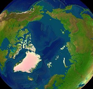
The Arctic Ocean, located in the Northern Hemisphere and mostly in the Arctic north polar region, is the smallest, and shallowest of the world's five major oceanic divisions.[1] The International Hydrographic Organization (IHO) recognizes it as an ocean, although some oceanographers call it the Arctic Mediterranean Sea or simply the Arctic Sea, classifying it as one of the mediterranean seas of the Atlantic Ocean.[2] Alternatively, the Arctic Ocean can be seen as the northernmost lobe of the all-encompassing World Ocean.
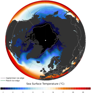
Almost completely surrounded by Eurasia and North America, the Arctic Ocean is partly covered by sea ice throughout the year[3] (and almost completely in winter). The Arctic Ocean's temperature and salinity vary seasonally as the ice cover melts and freezes;[4] its salinity is the lowest on average of the five major oceans, due to low evaporation, heavy freshwater inflow from rivers and streams, and limited connection and outflow to surrounding oceanic waters with higher salinities. The summer shrinking of the ice has been quoted at 50%.[1] The National Snow and Ice Data Center (NSIDC) uses satellite data to provide a daily record of Arctic sea ice cover and the rate of melting compared to an average period and specific past years.
Contents |
Geography
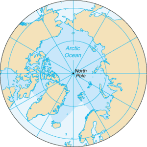
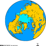
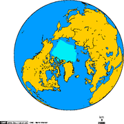
The Arctic Ocean occupies a roughly circular basin and covers an area of about 14,056,000 km2 (5,427,000 sq mi), almost the size of Russia.[5] The coastline is 45,390 km (28,200 mi) long.[5] It is surrounded by the land masses of Eurasia, North America, Greenland, and by several islands.
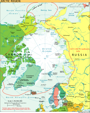
It is generally taken to include Baffin Bay, Barents Sea, Beaufort Sea, Chukchi Sea, East Siberian Sea, Greenland Sea, Hudson Bay, Hudson Strait, Kara Sea, Laptev Sea, White Sea and other tributary bodies of water. It is connected to the Pacific Ocean by the Bering Strait and to the Atlantic Ocean through the Greenland Sea and Labrador Sea.[1]
Extent
The International Hydrographic Organization defines the limits of the Arctic Ocean proper (that is, excluding the seas within the Ocean) as follows:[6]
Between Greenland and West Spitzbergen [sic] — The Northern limit of Greenland Sea.
Between West Spitzbergen and North East Land — the parallel of lat. 80°N.
From Cape Leigh Smith to Cape Kohlsaat — the Northern limit of Barentsz Sea [sic].
From Cape Kohlsaat to Cape Molotov — the Northern limit of Kara Sea.
From Cape Molotov to the Northern extremity of Kotelni Island — the Northern limit of Laptev Sea.
From the Northern extremity of Kotelni Island to the Northern point of Wrangel Island — the Northern limit of East Siberian Sea.
From the Northern point of Wrangel Island to Point Barrow — the Northern limit of Chuckchi Sea [sic].
From Point Barrow to Cape Land's End on Prince Patrick Island — the Northern limit of Beaufort Sea, through the Northwest coast of Prince Patrick Island to Cape Leopold M'Clintock, thence to Cape Murray (Brook Island) and along the Northwest coast to the extreme Northerly point; to Cape Mackay (Borden Island); through the Northwesterly coast of Borden Island to Cape Malloch, to Cape Isachsen (Ellef Ringnes Island); to the Northwest point of Meighen Island to Cape Stallworthy (Axel Heiberg Island) to Cape Colgate the extreme West point of Ellesmere Island; through the North shore of Ellesmere Island to Cape Columbia thence a line to Cape Morris Jesup (Greenland).
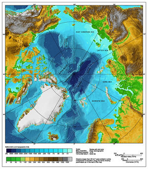
Underwater features
An underwater ridge, the Lomonosov Ridge, divides the deep sea North Polar Basin into two oceanic basins: the Eurasian Basin, which is between 4,000 and 4,500 m (13,000 and 14,800 ft) deep, and the Amerasian Basin (sometimes called the North American, or Hyperborean Basin), which is about 4,000 m (13,000 ft) deep. The bathymetry of the ocean bottom is marked by fault-block ridges, abyssal plains, ocean deeps, and basins. The average depth of the Arctic Ocean is 1,038 m (3,406 ft).[7] The deepest point is in the Eurasian Basin, at 5,450 m (17,880 ft).
The two major basins are further subdivided by ridges into the Canada Basin (between Alaska/Canada and the Alpha Ridge), Makarov Basin (between the Alpha and Lomonosov Ridges), Fram Basin (between Lomonosov and Gakkel ridges), and Nansen Basin (Amundsen Basin) (between the Gakkel Ridge and the continental shelf that includes the Franz Josef Land).
Water flow
The Arctic Ocean contains a major choke point in the southern Chukchi Sea,[8] which provides access to the Pacific Ocean through the Bering Strait between Alaska and Eastern Siberia. Subject to ice conditions, the Arctic Ocean provides the shortest marine link between the extremes of eastern and western Russia. There are several floating research stations in the Arctic, operated by the US and Russia.
The greatest inflow of water comes from the Atlantic by way of the Norwegian Current, which then flows along the Eurasian coast. Water also enters from the Pacific via the Bering Strait. The East Greenland Current carries the major outflow.
Ice covers most of the ocean surface year-round, causing subfreezing air temperatures much of the time. The Arctic is a major source of very cold air that moves toward the equator, meeting with warmer air at latitude 60°N and causing rain and snow. This flow is the lower portion of the polar cell, the highest (by latitude) of the three principal circulation cells of the Earth's atmosphere each spanning thirty degrees of latitude. Marine life abounds in open areas, especially the more southerly waters. The ocean's major ports are the cities of Murmansk, Arkhangelsk and Prudhoe Bay.[8]
Shelves
The Arctic Ocean is encompassed by the Arctic shelves, one of which, the Siberian Shelf, is the largest on Earth.
History
For much of European history, the North Polar regions remained largely unexplored and their geography conjectural. Pytheas of Massilia recorded an account of a journey northward in 325 BC, to a land he called "Eschate Thule," where the Sun only set for three hours each day and the water was replaced by a congealed substance "on which one can neither walk nor sail." He was probably describing loose sea ice known today as "growlers", or "bergy bits." His "Thule" may have been Iceland, though Norway is more often suggested.[9]
Early cartographers were unsure whether to draw the region around the North Pole as land (as in Johannes Ruysch's map of 1507, or Gerardus Mercator's map of 1595) or water (as with Martin Waldseemüller's world map of 1507). The fervent desire of European merchants for a northern passage to "Cathay" (China) caused water to win out, and by 1723 mapmakers such as Johann Homann featured an extensive "Oceanus Septentrionalis" at the northern edge of their charts.
The few expeditions to penetrate much beyond the Arctic Circle in this era added only small islands, such as Novaya Zemlya (11th century) and Spitsbergen (1596), though since these were often surrounded by pack-ice their northern limits were not so clear. The makers of navigational charts, more conservative than some of the more fanciful cartographers, tended to leave the region blank, with only fragments of known coastline sketched in.
This lack of knowledge of what lay north of the shifting barrier of ice gave rise to a number of conjectures. In England and other European nations, the myth of an "Open Polar Sea" was persistent. John Barrow, long time Second Secretary of the British Admiralty, promoted exploration of the region from 1818 to 1845 in search of this.
In the United States in the 1850s and '60s, the explorers Elisha Kane and Isaac Israel Hayes both claimed to have seen part of this elusive body of water. Even quite late in the century, the eminent authority Matthew Fontaine Maury included a description of the Open Polar Sea in his textbook The Physical Geography of the Sea (1883). Nevertheless, as all the explorers who travelled closer and closer to the pole reported, the polar ice cap is quite thick, and persists year-round.
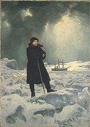
Fridtjof Nansen was the first to make a nautical crossing of the Arctic Ocean, in 1896. The first surface crossing of the ocean was led by Wally Herbert in 1969, in a dog sled expedition from Alaska to Svalbard with air support.
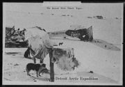
Since 1937, Soviet and Russian manned drifting ice stations have extensively monitored the Arctic Ocean. Scientific settlements were established on the drift ice and carried thousands of kilometres by ice floes.[10]
Climate
  |
|
| Extent of the Arctic ice-pack during the month of February, 1978-2002 average. | Extent of the Arctic ice-pack during the month of September, 1978-2002 average. |
Under the influence of the present ice age, the ocean is contained in a polar climate characterized by persistent cold and relatively narrow annual temperature ranges. Winters are characterized by continuous darkness (polar night), cold and stable weather conditions, and clear skies; summers are characterized by continuous daylight (midnight sun), damp and foggy weather, and weak cyclones with rain or snow.
The temperature of the surface of the Arctic Ocean is fairly constant, near the freezing point of seawater. Because the Arctic Ocean consists of saltwater the temperature must reach -1.8°C before freezing occurs. The density of sea water, in contrast to fresh water, increases as it nears the freezing point and thus it tends to sink. It is generally necessary that the upper 100–150 meters of ocean water cools to the freezing point for sea ice to form.[11] In the winter the relatively warm ocean water exerts a moderating influence, even when covered by ice. This is one reason why the Arctic does not experience the extreme temperatures seen on the Antarctic continent.
There is considerable seasonal variation in how much pack ice of the Arctic ice pack covers the Arctic Ocean. Much of the ocean is also covered in snow for about 10 months of the year. The maximum snow cover is in March or April — about 20 to 50 cm (7.9 to 20 in) over the frozen ocean.
Climate has varied significantly in the past; as recently as 55 million years ago, during the Paleocene–Eocene Thermal Maximum the region reached an average annual temperature of 10–20 °C (50–68 °F);[12] the surface waters of the northernmost[13] Arctic ocean warmed, seasonally at least, enough to support tropical lifeforms[14] requiring surface temperatures of over 22 °C (72 °F).[15]
Natural resources
Petroleum and natural gas fields, placer deposits, polymetallic nodules, sand and gravel aggregates, fish, seals and whales can all be found in abundance in the region.[8]
The political dead zone near the center of the sea is also the focus of a mounting dispute between the United States, Russia, Canada, Norway, and Denmark.[16] It is significant for the global energy market because it may hold 25% or more of the world's undiscovered oil and gas resources.[17]
Natural hazards
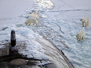
Ice islands occasionally break away from northern Ellesmere Island, and icebergs are formed from glaciers in western Greenland and extreme northeastern Canada. Permafrost is found on most islands. The ocean is virtually icelocked from October to June, and ships are subject to superstructure icing from October to May.[8] Before the advent of modern icebreakers, ships sailing the Arctic Ocean risked being trapped or crushed by sea ice (although the Baychimo drifted through the Arctic Ocean untended for decades despite these hazards).
Animal and plant life
Endangered marine species include walruses and whales.[8] The area has a fragile ecosystem which is slow to change and slow to recover from disruptions or damage.[8]
The Arctic Ocean has relatively little plant life except for phytoplankton. Phytoplankton are a crucial part of the ocean and there are massive amounts of them in the Arctic. Nutrients from rivers and the currents of the Atlantic and Pacific oceans provide food for the Arctic phytoplankton.[18] During summer, the Sun is out day and night, thus enabling the phytoplankton to photosynthesize for long periods of time and reproduce quickly. However, the reverse is true in winter where they struggle to get enough light to survive.[18]
Arctic jellyfish are also abundant in the waters of the Arctic.
Environmental concerns
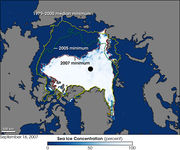
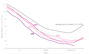
The polar ice pack is thinning, and in many years there will be seasonal hole in the ozone layer.[20] Reduction of the area of Arctic sea ice reduces the planet's average albedo, possibly resulting in global warming in a positive feedback mechanism.[21] Research shows that the Arctic may become ice free for the first time in human history between 2012 and 2040.[22]
Many scientists are presently concerned that warming temperatures in the Arctic may cause large amounts of fresh meltwater to enter the North Atlantic, possibly disrupting global ocean current patterns. Potentially severe changes in the Earth's climate might then ensue.[21]
Other environmental concerns relate to the radioactive contamination of the Arctic Ocean from, for example, Russian radioactive waste dump sites in the Kara Sea[23] and Cold War nuclear test sites such as Novaya Zemlya.[24]
Major ports and harbors
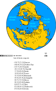
Some notable ports and harbours from west to east include:
- United States
- Barrow, Alaska
- Prudhoe Bay, Alaska[8]
- Canada
- Churchill, Manitoba
- Inuvik, Northwest Territories
- Nanisivik, Nunavut[25]
- Tuktoyaktuk
- Norway
- Longyearbyen
- Kirkenes
- Vardø
- Russia
- Murmansk[8]
- Arkhangelsk
- Labytnangi/Salekhard
- Dudinka
- Igarka
- Dikson
- Tiksi
- Pevek
See also
- Arctic Bridge
- Fauna of the Arctic
- Extreme points of the Arctic
- International Arctic Science Committee
- Nordicity
- North Atlantic Current
- Subarctic
- Explorers of the Arctic
- Arctic sea ice ecology and history
- Seven seas
- The Chukchi Cap
References
- ↑ 1.0 1.1 1.2 Michael Pidwirny (2006). "Introduction to the Oceans". www.physicalgeography.net. http://www.physicalgeography.net/fundamentals/8o.html. Retrieved 2006-12-07.
- ↑ Tomczak, Matthias; Godfrey, J. Stuart (2003). Regional Oceanography: an Introduction (2 ed.). Delhi: Daya Publishing House. ISBN 81-7035-306-8. http://www.es.flinders.edu.au/~mattom/regoc/
- ↑ Since the beginning of the 21st century, sea ice covers only 1/3 to 1/2 the surface of the Arctic Ocean at the end of summer.
- ↑ Some Thoughts on the Freezing and Melting of Sea Ice and Their Effects on the Ocean K. Aagaard and R. A. Woodgate, Polar Science Center, Applied Physics Laboratory University of Washington, January 2001. Retrieved 7 December 2006.
- ↑ 5.0 5.1 Wright, John W. (ed.); Editors and reporters of The New York Times (2006). The New York Times Almanac (2007 ed.). New York, New York: Penguin Books. pp. 455. ISBN 0-14-303820-6.
- ↑ "Limits of Oceans and Seas, 3rd edition". International Hydrographic Organization. 1953. http://www.iho-ohi.net/iho_pubs/standard/S-23/S23_1953.pdf. Retrieved 6 February 2010.
- ↑ "The Mariana Trench - Oceanography". www.marianatrench.com. 2003-04-04. http://www.marianatrench.com/mariana_trench-oceanography.htm. Retrieved 2006-12-02.
- ↑ 8.0 8.1 8.2 8.3 8.4 8.5 8.6 8.7 Arctic Ocean CIA World Factbook. 30 November 2006. Retrieved 7 December 2006.
- ↑ Pytheas Andre Engels. Retrieved 16 December 2006.
- ↑ North Pole drifting stations (1930s-1980s)
- ↑ "NSIDC sea ice". http://nsidc.org/seaice/intro.html. Retrieved 2010-02-10.
- ↑ Shellito, C.J.; Sloan, L.C.; Huber, M. (2003). "Climate model sensitivity to atmospheric CO2 levels in the Early-Middle Paleogene". Palaeogeography, Palaeoclimatology, Palaeoecology 193 (1): 113–123. doi:10.1016/S0031-0182(02)00718-6.
- ↑ Drill cores were recovered from the Lomonosov Ridge, presently at 87°N
- ↑ the dinoflagellates Apectodinium augustum
- ↑ Sluijs, A.; Schouten, S.; Pagani, M.; Woltering, M.; Brinkhuis, H.; Damsté, J.S.S.; Dickens, G.R.; Huber, M.; Reichart, G.J.; Stein, R.; Others, (2006). "Subtropical Arctic Ocean temperatures during the Palaeocene/Eocene thermal maximum". Nature 441 (7093): 610–613. doi:10.1038/nature04668. PMID 16752441.
- ↑ The Arctic's New Gold Rush - BBC
- ↑ The Battle for the Next Energy Frontier: The Russian Polar Expedition and the Future of Arctic Hydrocarbons, by Shamil Midkhatovich Yenikeyeff and Timothy Fenton Krysiek, Oxford Institute for Energy Studies, August 2007
- ↑ 18.0 18.1 Physical Nutrients and Primary Productivity Professor Terry Whiteledge. National Oceanic and Atmospheric Administration. Retrieved 7 December 2006.
- ↑ Continued Sea Ice Decline in 2005 Robert Simmon, Earth Observatory, and Walt Meier, NSIDC. Retrieved 7 December 2006.
- ↑ Clean Air Online - Linking Today into Tomorrow
- ↑ 21.0 21.1 Earth - melting in the heat? Richard Black, 7 October 2005. BBC News. Retrieved 7 December 2006.
- ↑ Russia the next climate recalcitrant Peter Wilson, 17 November 2008, The Australian. Retrieved 2 February 2009.
- ↑ 400 million cubic meters of radioactive waste threaten the Arctic area Thomas Nilsen, Bellona, 24 August 2001. Retrieved 7 December 2006.
- ↑ Plutonium in the Russian Arctic, or How We Learned to Love the Bomb Bradley Moran, John N. Smith. Retrieved 7 December 2006.
- ↑ "Backgrounder - Expanding Canadian Forces Operations in the Arctic". http://www.pm.gc.ca/eng/media.asp?id=1785. Retrieved 2007-08-17. mirror
Further reading
- Neatby, Leslie H., Discovery in Russian and Siberian Waters 1973 ISBN 0-8214-0124-6
- Ray, L., and bacon, B., eds., The Arctic Ocean 1982 ISBN 0-333-31017-9
- Thorén, Ragnar V. A., Picture Atlas of the Arctic 1969 ISBN 0-8214-0124-6
External links
- The Hidden Ocean Arctic 2005 Daily logs, photos and video from exploration mission.
- Oceanography Image of the Day, from the Woods Hole Oceanographic Institution
- Arctic Council
- The Northern Forum
- Arctic Environmental Atlas Interactive map
- NOAA Arctic Theme Page
- Arctic Ocean entry at The World Factbook
- Daily Arctic Ocean Rawinsonde Data from Soviet Drifting Ice Stations (1954-1990) at NSIDC
- Arctic time series: The Unaami Data collection
- NOAA North Pole Web Cam Images from Web Cams deployed in spring on an ice floe
- NOAA Near-realtime North Pole Weather Data Data from instruments deployed on an ice floe
- Search for Arctic Life Heats Up by Stephen Leahy
- International Polar Foundation
- National Snow and Ice Data Center - Daily report of Arctic ice cover based on satellite data
- Marine Biodiversity Wiki
|
|||||||||||||||||||||||||||||||||||||
|
||||||||||||||||||||
|
||||||||||||||||||||||||||||||||